Durham, NC Priority Trails

Durham Priority Trails
Trails in Durham provide residents with opportunities for transportation, recreation, and wellness, and strengthen connections within and between neighborhoods. Expanding and improving Durham’s trail system will provide these opportunities and connections to a greater number of residents and can play an integral role in achieving these goals. Which is why the City of Durham identified five priority trails that, when built, will have the greatest and most beneficial impact on residents where they live, work, and play in Durham.

Durham Priority Trails Demographics
10.72 MILES OF TRAIL
27,135 PEOPLE
9,436 FAMILIES living below twice the poverty rate
9,889 HOUSEHOLDS WITH NO ACCESS TO A VEHICLE
6,660 YOUTH UNDER 18
22,017 PEOPLE OF COLOR
TOTAL: $5,397,600
The five priority trails are: Pearsontown Trail, Bryant Bridge North/ Goose Creek West Trail, Sandy Creek Trail, North Ellerbee Creek Trail, and Third Fork Creek Trail. The goal of this brochure is to present a graphic and written guide for Durham’s five priority trails. It outlines a feasible route for each trail and includes connection opportunities, demographic analyses, and design and construction costs.

This trail begins at the Elmira Avenue Park, just to the east of that park’s junction with the American Tobacco Trail. It proceeds north through College View neighborhood until it reaches the NC Central University Campus (NCCU), where it connects to a wide pedestrian-and bike-friendly sidewalk through campus. The existing section of trail between Elmira Park and NCCU will be upgraded. The proposed trail extension then moves north along Grant Street, connects to Grant Park and the surrounding residences, and passes through the abandoned Fayette Place housing development; it ends at Hayti Heritage Center. The Southside neighborhood is a three block walk from the northern start to the trail. A future spur of the trail could follow Grant Street under the Durham Freeway connecting to the proposed light rail station and the John Avery Boys and Girls Club.
1) Elmira Avenue Park 2) Fayetteville Street Elementary School 3) Shepard Middle School 4) NC Central University Campus 5) Grant Park 6) Lincoln Community Health Center 7) WD Hill Recreation Center 8) Whitted Middle School 9) Stanford L. Warren Branch Library 10) WG Pearson Magnet Middle School 11) Former Fayette Place Housing Development 12) Hayti Heritage Center 13) Heritage Square Commercial District 14) Bryant Bike and Pedestrian Bridge

R. Kelly Bryant Bridge, completed in 2010, allows neighborhoods on both sides of Durham Freeway to reconnect. Upgrades to sidewalks and on-street facilities north of the bridge will provide a safe pedestrian and bike route to Pettigrew Street, the location of the proposed Light Rail Station and current Durham Green Flea Market. The trail will move north along Goley Street and connect to Eastway Avenue for residents to enjoy the Goose Creek restoration. The trail will follow along Goose Creek, creating a green thread that will link three Durham parks: Long Meadow Park, East End Park, and Drew-Granby Park. The trail could also serve as a connector to the proposed Duke Beltline.
1) Bryant Bike & Pedestrian Bridge 2) Proposed Alston Light Rail Station 3) Durham Green Flea Market 4) Holton Career & Resource Center 5) Eastway Elementary School 6) Goose Creek Restoration Project 7) Proposed Alston Avenue Improvements 8) Long Meadow Park 9) East End Park 10) Drew/Granby Park
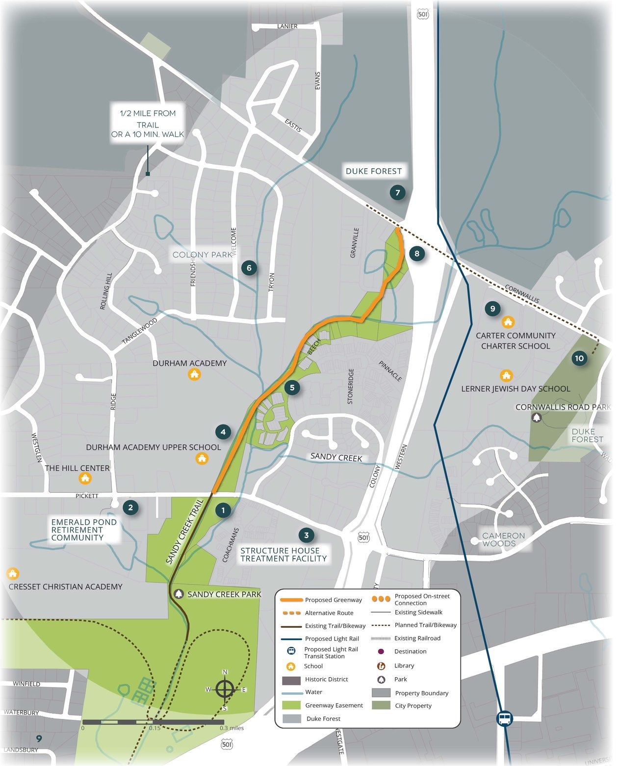
Sandy Creek Park is a destination park for viewing birds and wildlife in their native habitat and is a Monarch Way Station. Opening the trail to both the north and south would enable more park users to get to the park by foot or bike. The current trail runs from Sandy Creek Park north to Pickett Road. The proposed extension would move northward, across Pickett Road, with the installation of a high visibility crosswalk. The trail will follow along the southeast side of Sandy Creek behind the Colony Park and Beach Hill communities. A majority of easements along this section of the trail have been granted and/or are on record.
1) Sandy Creek Park 2) Emerald Pond Retirement Community 3) Structure House Treatment Facility 4) Durham Academy 5) Beach Hill Community 6) Colony Park Community 7) Duke Forest 8) Planned Cornwallis on-street bike route 9) Carter Community Charter School 10) Cornwallis Road Park

The North Ellerbee* Creek Trail is a proposed natural surface walking trail that has the potential to link the Mountains to Sea Trail to the Beaver Marsh Nature Preserve. Much of the corridor is owned by the Army Corps of Engineers, the City of Durham, or Ellerbe Creek Watershed Association (ECWA). This section of the trail will end at the ECWA Glennstone Nature Preserve with future prospects to connect to the Mountains to Sea Trail. There are many scenic stretches along the creek, including a heron rookery located on City Property just off the trail.
1) Ellerbee Creek Trail 2) Club Boulevard School 3) Northgate Park 4) Beaver Marsh Nature Preserve 5) Location of proposed trailhead with parking 6)Glennstone Nature Preserve 7) Blue Heron Rookery 8) Mountains to Sea Trail

Third Fork Creek Trail begins at Garrett Road Park and ends at Southern Boundaries Park. The proposed extension of Third Creek Trail will connect to existing trail in Southern Boundaries Park. The trail will continue along the northwest side of Third Fork Creek, crossing wetlands and streams that will most likely require boardwalks or bridges. The trail continues to Cornwallis Road, and a sidewalk continues along the north side of Cornwallis to Fayetteville for an easy connection to the American Tobacco Trail (ATT) at Pilot. The sidewalk also crosses Fayetteville Street onto WG Pearson Elementary School Property for another potential connection to the ATT.
1) Southern Boundaries Park 2) Barnhill Street and location of proposed trailhead with parking 3) Cornwallis Road 4) Weaver Street Recreation Center 5)American Tobacco Trail